Excursions
The main hiking trails identified in the territories of the Regional Nature Reserve of the Lake of Cornino are listed below.
As with any cross-country trekking activity (and not only) carried out with the proper attention, we remind you to take in consideration the following safety precautions before engaging the walking activity:
– Avoid taking any route, especially if in a highly tree-lined area or in slippery or sloping terrain, if the weather conditions are bad;
– Evaluate the altimetric and kilometric features of the comparing them also (and above all) to your experience and your level of training;
– Avoid making excursions if your physical conditions are altered or inoptimal, especially in the (very understandable ..) eventuality in which alcoholic beverages have been drunk;
– Avoid making excursions in extreme temperatures, especially if you are not experienced or badly equipped;
– Always evaluate the difficulties related to the travel of certain iters in the presence of old people or children: in some cases, it is absolutely impossible for prams or strollers to complete the path;
– To protect the highest possible quiet towards the animal world and to limit the already very low percentage of accidents, avoid dressing in bright colors and with uncovered shoes;
– Remember that killing wildlife (including vipers and presumed ones) is a crime to the Italian jurisdiction, punished also with arrest; you will be held responsible for the actions of your dogs and other pets too;
– We recommend, of course, adequate equipment for the desired excursion.
For information on the trails outlined below: Natural Reserve of the Lake of Cornino tel. 0427.808526.
Paths around the Reserve:
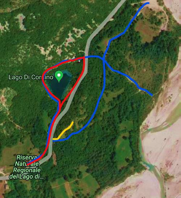
1) THE LAKE PATH
Duration: 40 minutes
Start and finish: Visitor Centre of the Reserve
Length: 1.48 Km
Highest point: 203 m a.s.l. at the wooden bridge
Lowest point: 185 m a.s.l. at the lake
The ring walk begins by taking the path on the right of the gate to the Visitor Center. Walking along a retaining wall you will reach a resting area equipped with tables and benches, situated in the shade of a grove of hornbeams, flowering ash, and downy oaks. The route continues descending along a metal staircase reaching a crossroad. Keeping left, the path descends to the basin of the lake along the banks on the upstream side.
The transparency of the lake’s waters allows to admire the emerald colors linked to the presence of some species of algae. On the rocky walls overlooking the lake, at the northern limit, you can observe a mediterranean vegetation consisting of european smoketrees, terebinth and holm oak. The crumbling of the rocky walls also originated landslide deposits consisting of characteristic limestone boulders in which fossils of Ellipsactiniae abound.
As you reach the provincial road SP22, turn right.
At this point, the returning path coincides for a short stretch with the road before skirting it, thus allowing a complete view of the lake.
Variation: climb to the OBSERVATORY
Duration: 10 min round trip
Altitude Observatory: 218 m a.s.l. at the observatory
After passing the resting area at the beginning of the path, take the wooden bridge on the right that connects the path to the observatory built on the reached hill, point from which a beautiful view of the Tagliamento River and the surrounding area can be enjoyed.
2) THE TAGLIAMENTO PATH
Duration: 50 minutes
Start and finish: Visitor Centre of the Reserve
Lenght: 1.54 Km
Highest point: 203 m a.s.l. at the wooden bridge
Lowest point: 155 m at the meadow on the Tagliamento
Path suitable for those who want to visit the Lake Cornino appreciating the surrounding natural environments as well, but without joining a challenging walk.
The excursion begins by taking the path on the right of the Visitor Center’s gate and coincides with the already described path of the lake until the reaching of the provincial road SP22. Here, instead of turning right, cross the road to get a downhill path that leads to a glade near the bed of the Tagliamento River. Continue keeping right until you reach the end of the grove: on the right you will find a cart track used by the locals to access the landed properties. Keep going on along this path immersed in groves of hazelnut, hornbeam, ash and dogwood, species that leave spaces, from time to time, to old plots of land once used for haymaking.
Past a dry-stone wall, in correspondence with an old inscription, a narrow path winds on the right leading to the back of the wooden bridge, allowing you to join the way of return.
PS: After reaching the glade driving to the crossroad, it is possible to reach the pebbly shore and the river bank.
It is also possible to enjoy the panoramic view of the lake from two different observation points: you can take the right deviation along the road, localized at the initial junction near the lake, or alternatively the right detour localized at the intersection between the end of the lake path and the provincial road (See Map)
The path allows to reach the observatory as well, both at the beginning and at the end of the walk, as the path closes in a loop.
Variation: climb up to the OBSERVATORY
Duration: 10 min round trip
Observatory Altitude: 218 m a.s.l. at the observatory
On this route you can climb up to the observatory both at the beginning of the walk (see the variation for the Lake Path) and at the end when the path closes in a loop.
3) SOMPCORNINO-LEDRANIA-PEONIS PATH
Duration: 2 ½ hours
Altitude difference: 450 m
Lenght: about 5 Km
CAI paths: 817, 818
Start: village of Sompcornino (Municipality of Forgaria in Friuli)
Arrival: village of Peonis (Municipality of Trasaghis)
The trail initially runs within the municipality of Forgaria in Friuli and then continues within the municipality of Trasaghis. The initial climb takes place in a wild environment with extensive screens and stretches of rockface. The trail is well marked (CAI no. 817) and starts in the village of Cornino Somp (170 m). Rapidly leaving the last houses behind and oassing stretches of scrub and patches of trees, beautiful stone walls border the route, evidence of traditional agricultural practices. Higher up we encounter large clearings, with patches of trees arboreal vegetation consists predominantly of hop hornbeam Ostrya carpinifolia, downy oak Quercus pubescens, flowering ash Fraxinus ornus, cornalian cherry Cornus mas and hazel Corylus avellana. The varied environment favours the presence of many animal species, such as roe deer Capreolus capreolus, badger Meles meles and birds including the red-backed shrike Lanius collurio, various tit species (Paridae) and numerous other passerines. Having passed through this area, after 15-20 minutes and passing two forks, you will soon reach some broad scree slopes. The trail climbs several curves, almost always among beautiful stone walls that are home to a rich and unusual flora of aromatic plants such a winter savory Satureja variegata and the calamint Micromeria thymifolia. This is the environment preferred by the horn-nosed viper Viper ammondytes, the wall lizard Podarcis muralis, the rock bunting Emberizia cia and the nightjar Caprimulgus europaeus, as well as small mammals and insects such as butterflies and grasshoppers. The track continues to climb, approaching rocky areas used as perches by raptors and corvids. The entire route allows you, in fact, to admire the majestic flight of the griffon vulture Gyps fulvus, which, along with ravens Corvus corax and other birds of prey, perform spectacular aerial tricks.
Towards the end of the route the rocky slopes are steep and covered with a woody vegetation with the characteristic crub of evergreen holm oak Quercus ilex, particularly conspicuous during the winter. The route continues with long stretch of stone steps until, after about an hour, it reaches a wooden cross on the road at Borgo Ledrania Cornino. Having descended an hundred metres or so along the paved road, turn left onto the trail that leads to Stavoli Pecol by Zochs (the trail is marked n°818) through grassy clearings surrounded by dense scrub.
On the now-abandoned meadows you can admire beautiful spring flowers including wild daffodils Narcissus radiflorus and asphodels Asphodelus albus or, in summer, the showy peonies Paeonia officinalis and fragrant dittany Dictamnus albus.
This sction of trail also offers broad views across the Plains of Osoppo, the Moraine Amphitheater and the Julian Alps. Shortly before the Stavoli, the trail runs along the top of the cordon of the moraine that marks the maximum expansion of the Tagliamento glacier. an event that occurred about 20,000 years ago.
Here, blocks consisting of “exotic” rocks from the Carnic Alpine Chain are frequent and easily recognizable for their vibrant colout and the presence of rounded pebbles of flint.
The descent towards Peonis takes place along a easy shaded by a dense thicket of thermophilic scrub.
At the end of the mule-track, take the SP22 to return to Cornino that, from here, is about 5 km distant. The time required for the return from Peonis towards Cornino is not counted in the journey time indicated at the beginning as 2½ hours.